
A complete guide covering the most commonly asked land survey interview questions.
1. Basics of Land Surveying
Q: What is land survey?
Land survey is a process of measuring angles, distances and heights of points to know their positions, in order to determine the actual shape and ground surface.
Q: What are the types of survey?
Land surveying is divided into two types:
1. Geodetic survey
The earth’s surface is considered curved, and relative corrections are made in measured data. It is performed at large scales and is a precise survey in terms of accuracy.
2. Plane survey
The surface of the earth is considered plane, and the curvature of the earth is not taken into account. This type is suitable for small areas, and its accuracy is comparatively less than geodetic survey.
Q: What are the operations/works in survey?
- Control Survey
- Boundary Survey
- Topographic Survey
- Hydrographic Survey
- Mining Survey
- Construction Survey
- Route Survey
- Photogrammetric Survey
2. Curves in Surveying
Q: Define curve.
Curves are provided to smooth the flow of traffic when the centre line of a track deflects in a horizontal or vertical plane. There are two types of curves.
- Horizontal Curves
- Vertical Curves
Horizontal Curves
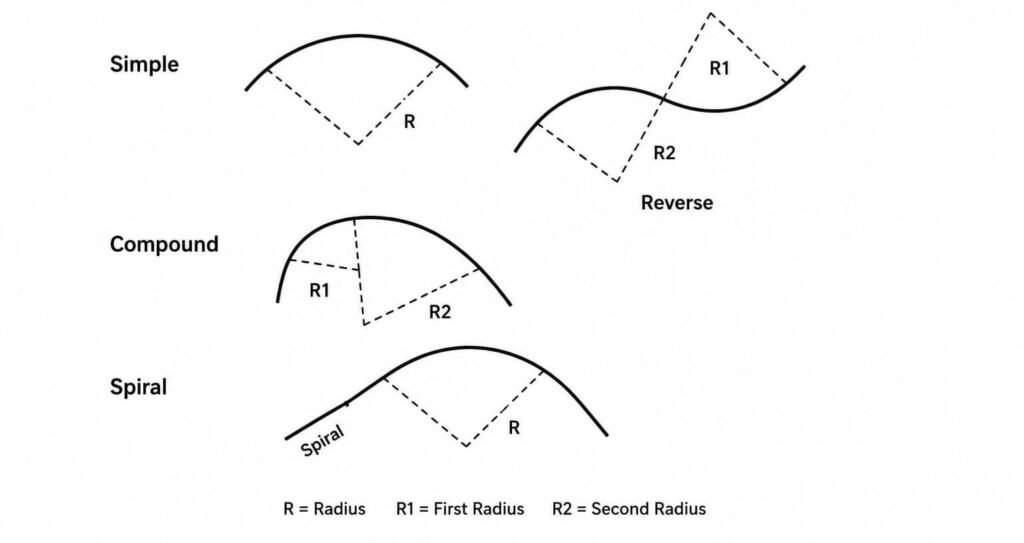
These curves are used when the centre line deflects in the horizontal plane and are divided into four types:
1. Simple curve
A single circular line with a uniform radius.
2. Compound curve
A combination of two simple curves having different radius, where the centre point of both is on the same side.
3. Reverse curve
A combination of two or more curves of the same or different radius, where the centre point of each curve is opposite to the other.
4. Transit or spiral curve
A curve of constantly changing radius, used to connect a simple curve to a straight line or to a curve of a different radius.
Vertical Curves
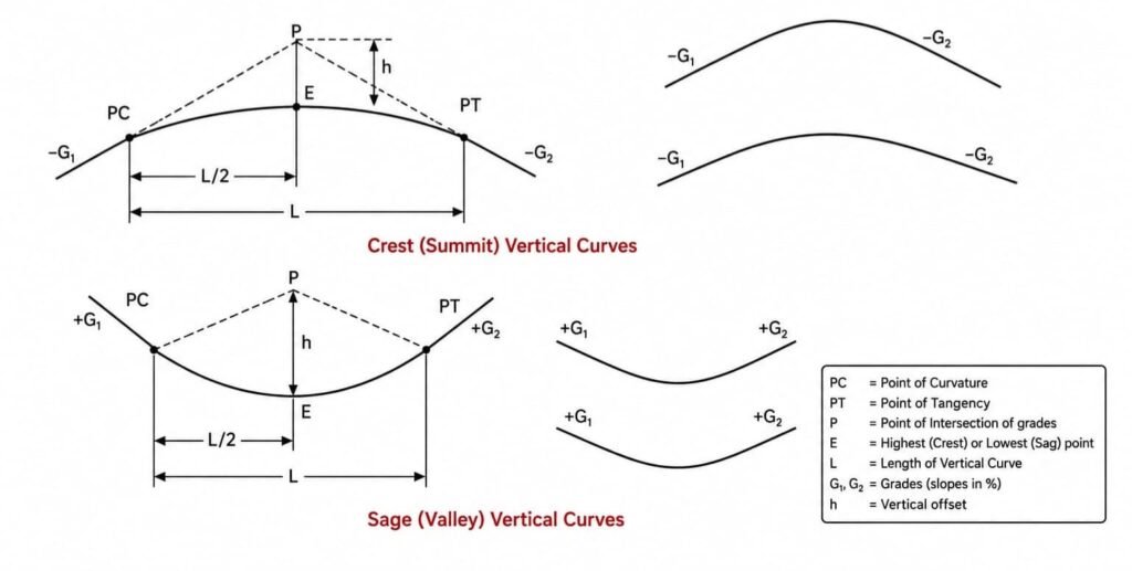
These curves are used when the track deflects in the vertical plane and are divided into two types:
1. Crest or Summit curves
2. Sag or Valley curves
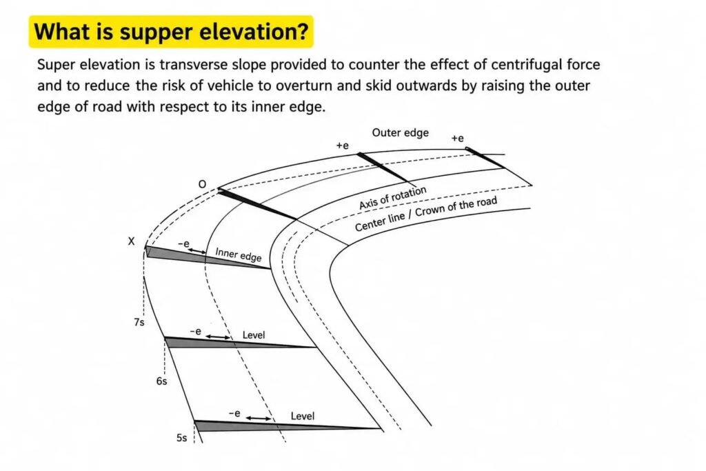
Q: What is super elevation?
Super elevation is the transverse slope provided to counter the effect of centrifugal force and to reduce the risk of a vehicle overturning and skidding outwards, by raising the outer edge of the road with respect to its inner edge.
3. Errors, Accuracy & Direction
Q: What is random error and systematic error?
- Random errors are not predictable and not in the control of the surveyor.
- Systematic errors are predictable and can be controlled and minimized by the surveyor.
Q: What is the difference between accuracy and precision?
- Accuracy is the degree of conformity of given values with its standard value.
- Precision is the extent to which a given set of measurements agree with their mean value.
Q: What is true north, grid north and magnetic north?
- True north – Its direction along the surface of the earth towards the geographical north pole.
- Grid north – A direction directing towards the north direction along the grid lines of a map.
- Magnetic north – A direction shown by a compass needle in repose of earth’s magnetic field.
4. Maps & Coordinate Systems
Q: Define large scale and small scale maps.
- Large scale maps show a small area with greater detail and are used to show the cities and topographic details of an area.
- Small scale maps show a larger area with less detail and are used to show the major features of the earth, such as mountains and country borders.
Q: What are coordinate systems?
Geographical coordinates
This system uses the three-dimensional spherical earth surface to show the position of points, and values are presented in latitude and longitude forms.
Cartesian coordinates
In this system, the position of points is specified by numerical values with reference to a fixed point, presented in easting and northing forms.
5. Triangulation & Trilateration
Q: What is triangulation?
In this method, angles are measured in the field with respect to a pre-defined base, and then distances are calculated with respect to the measured angles and the length of the baseline.
Q: What is trilateration?
Trilateration is a method to extend the horizontal control by measuring the lengths of triangles, and then their angles are calculated from the measured distances.
6. Survey Instruments
Q: What is the difference between a total station and an electronic theodolite?
Theodolites are used for the measurement of horizontal and vertical angles, whereas a total station can measure and store the angles and distances.
Q: What are the two main methods to work out the level of a point in the field?
- Collimation method
- Rise and fall method
7. GPS, RTK & Related Technologies
Q: What is a GPS system?
GPS is a satellite-based navigational system used to determine the 3D position of an object.
Q: What is RTK, and how does it work?
Real Time Kinematic (RTK) is used to increase the accuracy of GPS by using a fixed base station, which sends corrections to a moving rover through satellites.
Q: What is a Rover?
A Rover is a survey instrument used to receive the signal from the base, through satellite, to determine the horizontal and vertical grades.
Q: What are the uses of coordinates?
Coordinates are used to specify the positions of objects and points.
Q: What are slope stakes?
Slope staking is a special form of levelling used to determine the location where a proposed slope intersects the natural ground level.
8. Sights & Line of Collimation
Q: What is 1st sight?
The 1st reading taken after setting up a survey instrument is called the 1st sight or backsight.
Q: What is inter sight?
All the readings taken between the backsight and foresight are called inter sights.
Q: What is the line of collimation?
An imaginary line passing through the eyepiece and the centre of the cross hairs.
Q: Why does the elevation given in maps not agree with those provided by GPS?
Because both use different datums — most maps use NAD27, while GPS uses WGS84.
Q: What are the minimum and maximum backsight and foresight distances while shifting a benchmark?
The distance should be between 30 to 50 meters.
9. Precautions & Benchmarks
Q: What precautions need to be taken while establishing benchmarks?
Since errors in benchmarks will affect the networks established using these points, the following precautions need to be taken:
- High accuracy instrument should be used.
- Level instrument adjustment needs to be tested.
- Parallax should be eliminated by proper focusing.
- Staff must be in a vertical position.
- Points should be made on stable ground surface to avoid settlements.
- Level bubble should be exactly in the centre while taking the reading.
- Length of sight may not exceed 100m.
- Backsight and foresight distances should be nearly equal.
Q: What is grid distance and ground/geodetic distance?
Grid distance is a measurement in which the surface of the earth is considered plane.
Q: What is scale factor?
The ratio of change between two corresponding lengths or distances is called the scale factor.
Q: What are the precautions in precise levelling, and why are they necessary?
- This levelling is used to establish benchmarks at long distances, and it is a time-consuming and costly process.
- These benchmarks are used by others to establish local networks, so any error in these benchmarks will affect the networks established using these points.
10. Common Terms & Abbreviations
| Abbreviation | Full Form |
|---|---|
| GPS | Geographic Positioning System |
| MSL | Mean Sea Level |
| DTM | Digital Terrain Model |
| GIS | Geographic Information System |
| CORS | Continuously Operating Reference System |
| VRS | Virtual Reference System |
Comments